Using Marine Navigation Apps for Efficient Trip Planning
Marine navigation has evolved from using charts and compasses to integrating advanced technology. Marine navigation apps have become essential for mariners, offering a blend of accuracy, convenience, and real-time information that enhances trip planning and on-the-water navigation.
This blog post will explore how using the best marine navigation apps can lead to more efficient trip planning, safer voyages, and a more enjoyable maritime experience.
Why Marine Navigation Apps are Essential
Before diving into the specifics of marine navigation apps, it’s essential to understand why these tools are so crucial in today’s maritime environment. Here are a few reasons:
- Accuracy and Precision: Provides real-time updates for precise navigation, helping mariners stay informed and mitigate risks from changing weather or sea conditions.
- Comprehensive Data: This service offers integrated data like tide charts, weather forecasts, and vessel tracking, enabling informed decision-making and hazard preparation.
- Convenience: Allows route planning, weather checks, and vessel communication all from a single smartphone or tablet, simplifying the navigation process.
- Cost-Effectiveness: Many high-quality apps are affordable or free, offering a budget-friendly alternative to expensive traditional marine electronics.
Key Features of the Best Marine Navigation Apps
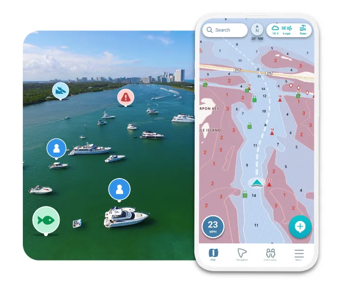
- Offline Capabilities: Provides access to essential maps and navigation data even when cellular signals are weak or unavailable, ensuring continuous guidance in remote areas.
- AIS Integration: This shows the real-time positions of nearby vessels, which is critical for avoiding collisions and enhancing safety in busy waterways.
- Route Planning and Optimization: Includes tools that factor in currents, wind, and tides to plan the most efficient route, helping to reduce travel time and fuel consumption.
- Weather and Tides Information: Offers real-time updates on weather conditions and tidal changes, allowing mariners to adjust their plans for safer and smoother trips.
- Social and Community Features: Lets users share routes, tips, and experiences with fellow boaters, adding a layer of community knowledge and support.
- Sonar and Chartplotter Integration: Provides detailed underwater data on topography and fish locations, particularly useful for fishing enthusiasts and commercial operators seeking accurate underwater information.
Efficient Trip Planning with Marine Navigation Apps
Efficient trip planning with marine navigation apps involves several key steps that ensure a safe and successful voyage:
- Pre-Trip Research: Use the app to research your intended route. Look at weather forecasts, tide information, and potential hazards. This initial preparation helps you anticipate challenges and plan your route more effectively.
- Route Plotting: Use the app’s route planning tools to plot your course, considering the current weather, tides, and vessel traffic. Some apps offer automatic route optimization, which suggests the best course based on real-time data, saving time and fuel.
- Download Offline Maps: If you plan to navigate areas with limited cellular coverage, download offline maps and data in advance. This ensures you can access critical navigation information even when your device is out of range.
- Check AIS Data: Before setting out, review AIS data to understand the traffic in your departure area and along your intended route. Knowing other vessels’ locations can help you avoid busy areas and plan a safer journey.
- Monitor Weather and Tides: As your departure date approaches, continue to monitor weather and tide information. Adjust your route or departure time if conditions change to avoid potential dangers.
- Real-Time Adjustments: While at sea, use the app’s real-time features to make necessary adjustments to your route. Whether rerouting due to unexpected weather or avoiding an obstacle.
Top Marine Navigation Apps
- Navionics offers detailed charts, offline maps, AIS integration, and real-time weather updates. Due to its comprehensive features and user-friendly interface, it is ideal for both professional and recreational boaters.
- C-MAP: Features extensive mapping, offline capabilities, and route planning. Its community-driven approach allows users to share routes and tips, enhancing the app’s value with shared experiences.
- iNavX: Supports charts from multiple providers, including Navionics and NOAA. Integrates with AIS, weather services, and chart plotters, making it a versatile and robust choice for serious mariners.
- Seapilot: Known for its AIS integration and user-friendly design. Provides detailed charts, weather forecasts, and route planning tools for recreational and professional use.
Conclusion
Marine navigation apps have significantly enhanced mariners’ planning and execution of voyages. These features enhance safety and efficiency on the water, making navigation easier for both seasoned sailors and casual boaters.
When selecting an app, consider your specific needs, such as offline capabilities, AIS integration, or social features. By choosing the right tools and using them effectively, you can ensure that your trips are efficient but also safe and enjoyable.


